Grand Forks, North Dakota Weather
Issued: 2:33 pm CDT May 5, 2024 Latitude: 47.9252568 Longitude: -97.0328547 View on Google Maps
|
|
|
|
|
|
|
|
|
|
 |
 |
 |
 |
|
 |
|
|
| High: °F |
Low: °F |
High: °F |
High: °F |
High: °F |
High: °F |
High: °F |
High: °F |
| Low: °F |
Low: °F |
Low: °F |
Low: °F |
Low: °F |
|
| Mostly Sunny |
Cloudy |
Partly Sunny |
Rain |
Rain |
Rain |
Mostly Sunny |
Mostly Sunny |
Current Conditions at
GRAND FORKS INTL - (KGFK)
63°
Partly Cloudy
as of 1:53 PM CDST
Rel. Humidity: 45%
Dew Point: 41°F
Visibility: 10 Miles
Pressure: 29.99 in.
Flight Rule: VFR
Wind Data
12 MPH
Gust: 17 MPH
120° Southeast
Cloud Level(s): Scattered at 6000ft
Current Conditions at
GRAND FORKS AFB - (KRDR)
66°
Partly Cloudy
as of 1:55 PM CDST
Rel. Humidity: 34%
Dew Point: 37°F
Visibility: 10 Miles
Pressure: 29.97 in.
Flight Rule: VFR
Wind Data
8 MPH
Gust: 17 MPH
160° South
Cloud Level(s): Scattered at 6000ft
Current Conditions at
CROOKSTON MUNICIPAL FIELD - (KCKN)
66°
Partly Cloudy
as of 2:15 PM CDST
Rel. Humidity: 27%
Dew Point: 32°F
Visibility: 10 Miles
Pressure: 30.01 in.
Flight Rule: VFR
Wind Data
9 MPH
Gust: 21 MPH
160° South
Cloud Level(s): Scattered at 7000ft
Current Conditions at
THIEF RIVER FALLS - (KTVF)
61°
Mostly Cloudy
as of 1:56 PM CDST
Rel. Humidity: 41%
Dew Point: 37°F
Visibility: 10 Miles
Pressure: 30.03 in.
Flight Rule: VFR
Cloud Level(s): Broken at 5500ft, Broken at 7000ft
|
This Afternoon... Mostly sunny, with a high near 67. South southeast wind around 9 mph. |
|
|
Tonight... Partly cloudy, with a low around 49. Southeast wind 10 to 17 mph, with gusts as high as 25 mph. |
|
|
Monday... A 30 percent chance of showers, mainly after 1pm. Partly sunny, with a high near 72. Breezy, with a southeast wind 18 to 28 mph, with gusts as high as 41 mph. New precipitation amounts of less than a tenth of an inch possible. |
|
 |
Monday Night... Showers and possibly a thunderstorm before 4am, then showers likely. Low around 54. Windy, with a southeast wind 26 to 31 mph, with gusts as high as 49 mph. Chance of precipitation is 80%. New rainfall amounts between a quarter and half of an inch possible. |
|
|
Tuesday... A 40 percent chance of showers. Mostly cloudy, with a high near 66. Breezy, with a south southeast wind 18 to 22 mph, with gusts as high as 34 mph. New precipitation amounts of less than a tenth of an inch possible. |
|
 |
Tuesday Night... A 20 percent chance of showers. Mostly cloudy, with a low around 47. South southeast wind 10 to 15 mph, with gusts as high as 23 mph. |
|
|
Wednesday... A 40 percent chance of showers, mainly after 1pm. Mostly cloudy, with a high near 66. East wind 9 to 15 mph, with gusts as high as 22 mph. |
|
 |
Wednesday Night... A 30 percent chance of showers, mainly before 1am. Mostly cloudy, with a low around 45. North northeast wind around 14 mph, with gusts as high as 21 mph. |
|
|
Thursday... A 30 percent chance of showers, mainly after 1pm. Mostly sunny, with a high near 63. North northeast wind 13 to 17 mph, with gusts as high as 25 mph. |
|
|
Thursday Night... Partly cloudy, with a low around 42. North northeast wind 9 to 15 mph, with gusts as high as 23 mph. |
|
|
Friday... Mostly sunny, with a high near 68. Northwest wind 9 to 14 mph, with gusts as high as 22 mph. |
|
|
Friday Night... Partly cloudy, with a low around 44. North northwest wind 9 to 15 mph, with gusts as high as 18 mph. |
|
|
Saturday... Mostly sunny, with a high near 71. West northwest wind 9 to 14 mph, with gusts as high as 21 mph. |
|
Current Radar Image
Sun Almanac for Grand Forks, North Dakota
Sunrise: 06:02 AM
Sunset: 8:47 PM
Civil Sunrise:05:27 AM
Civil Sunset: 9:23 PM
Nautical Sunrise: 04:42 AM
Nautical Sunset: 10:08 PM
Astro Sunrise: 03:48 AM
Astro Sunset: 11:01 PM
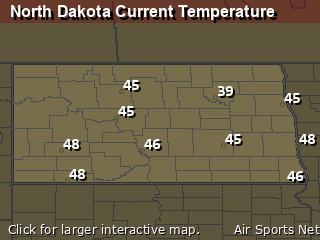
North Dakota's Current Temperatures
 North Dakota's Satellite Image
 North Dakota's Current Wind Direction
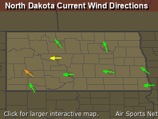
| National Summary |
of upper and lower values of current conditions amongst 7012 locations
in the contiguous United States |
|
High
Temp |
95° |
Jacksonville Cecil Fld, Florida
and 1 other location
|
|
Low
Temp |
30° |
Ely, Nevada
and 1 other location
|
|
Wind
Speed |
45mph |
El Centro, California
|
|
Wind
Gust |
66mph |
El Centro, California
|
|
Wind
Chill |
22° |
Alturas, California
and 1 other location
|
|
Heat
Index |
109° |
Ft Rucker/Hanche, Alabama
|
|
High
Pressure |
30.32Hg |
Coast Guard Air Sta, Massachusetts
|
|
Low
Pressure |
29.44Hg |
Worland, Wyoming
and 1 other location
|
|
| # Locations Reporting Snow |
4 |
|
| # Locations Reporting Rain |
210 |
|
| # Locations Reporting Thunderstorms / Lightning |
18 |
|
| # Locations Reporting Fog |
1 |
|
| Average Temperature in the Contiguous USA |
67° |
|
Any use of the information on this page is at your own risk. This information should not be relied upon in life-threatening situations, potential financial loss situations or in lieu of any officially disseminated information. Visit the
National Weather Service for official information.


